A few days ago I wrote an entry about a secret report about Caodaism from 1944. I found that report in a text called the Gazetteer of Indochina. This gazetteer was compiled by the Indochina Section of the Far Eastern Bureau of the British Ministry of Information in New Delhi during World War II.
The main part of the text consists of a list of the names of villages in French Indochina, as well as their latitudinal and longitudinal coordinates. I think the British compiled this information so that they would know, among other things, where to bomb.
In any case, as I looked at the list I noticed that there were many place names that began with the name “ban.” Sometimes transcribed in English as “baan,” this is a word for “village” that we can find in many Tai languages, such as Lao and Central Thai.
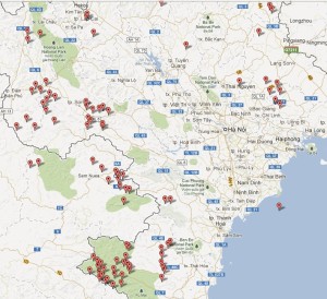
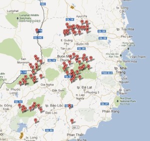
I was curious to know where place names that contained the term “ban” in Vietnam were, so I decided to map them out. There are many such place names in Laos, but I was interested to see where in Vietnam places that began with the term “ban” were.
I first spent some time inputting the place names and the coordinates into an Excel file. That was really annoying and boring!! 🙁
Once I had done that, however, creating the map was very easy. It was fun and exciting!! 🙂
I used an online program called BatchGeo. All I had to do was to copy the data from the Excel file, paste it in the space provided on the BatchGeo website (here), and click “Map Now.”
The results were interesting. First of all, one village ended up out in the sea. I double checked the coordinates, and I input them correctly, so the information in the Gazetteer of Indochina must be incorrect.
Another point that was interesting is that some of the place names that the Gazetteer of Indochina lists as being in Tonkin or Annam are today in Laos. I don’t know anything about the post-war history of that border, but it looks like it has changed.
It is also interesting that there is a cluster of villages in the South that start with the term “ban.” That was not an area where there were Tai-speaking peoples (as far as I know). Perhaps the term was used to refer to places where people who were not ethnically Vietnamese lived. However, if that was the case, then I would think that one would find the term more widely used in the Center and South.
So I’m curious to know why there were so many “ban” in that area. That said, the Gazetteer of Indochina must be based on gazetteers that the French made, and one has to wonder how accurate it is. So the obvious next step would be to consult gazetteers that the French made during the colonial era.
Finally, when you click on one of the markers for a place name, it provides the name that I input from the Gazetteer of Indochina, “Ban Ong” in the case above, and it also provides a current place name.
Again, I’m not sure how accurate any of this is yet, but this could potentially be a very helpful tool for connecting places during the colonial era with current place names (if they have changed).
I wanted to try this as I am interested in the digital humanities and this map is a good example of what digital tools can help us do. The digital humanities is to a large extent about making data visual so that we can see issues in a new light and ask new questions.
This exercise here in “mapping ban” shows, I think, that there is indeed a lot that we can do.
The actual map that I made can be accessed here.
[For the gazetteer, see the National Archives of Australia: NAA: A1067, PI46/2/4/1 Gazeteer of Indo China. Far Eastern Bureau.]


This Post Has 2 Comments
thank you!
You know what ? the Vietnamese communist authorities have replaced many indigenous place names such as ”ban”, ”muong”, ”po”, etc with new Vietnamese names out of political and culturally assimilational purposes. If not, you would see much more ”ban” and ”muong” in the map around the west of northern central, northwestern and northeastern parts of Vietnam. Now in the imaginations of an ordinary Vietnamese or even of a Vietnamese-ized minority, place names: ”ban” and ”muong” are associated with backwardness and uncivilize-ness as a result of communist propaganda portraying the peoples living in ”ban”, ”muong” as ”backward”, ”interior”, ”uncivilized” according to ”Vietnamese standards”. I’m convinced that the same process also happens in China.
The place name ”ban” in Central Highlands of south Vietnam is probably an imposed name during French colonial era since, as you said, the name does not exist in languages of indigenous peoples of the Central Highlands.